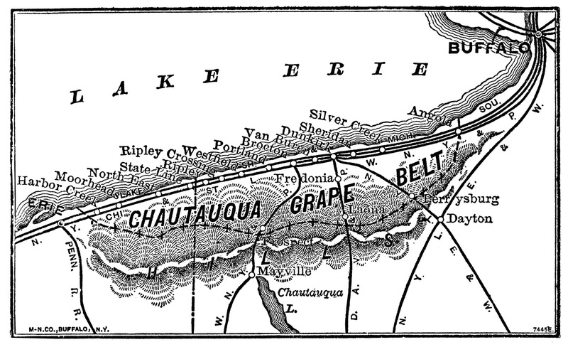
Chautauqua Grape Belt Townships Map
Item
-
Title
-
Chautauqua Grape Belt Townships Map
-
Identifier
-
4004.235a
-
Description
-
Black and white map showing the Chautauqua Grape Belt in New York and Pennsylvania. Lake Erie is depicted at the extreme top of the map, with the city of Buffalo noted at the top right corner. The towns are marked along the shore (but are not to scale), as well as the locations of train lines in the region and the Chautauqua Ridge marked as "HILLS."
Towns listed along the shore as follows from left to right: "Erie, Harbor Creek, Moorheads, North East, State Line, Ripley Crossing, Westfield, Portland, Brocton, Van Buren, Dunkirk, Sheridan, Silver Creek, Angola." Other towns listed along train lines: "Fredonia, Mayville, Perrysburg, Dayton."
The bottom left of the map includes the text "M-N. Co., Buffalo, N.Y." and the bottom right says "7445E."
-
Abstract
-
Map of townships in the Chautauqua Grape Belt including train lines related to the shipment of grape production.
-
Subject
-
Erie, PA
-
Harborcreek, PA
-
Moorheads, PA
-
North East, PA
-
State Line, PA
-
Ripley, NY
-
Westfield, NY
-
Portland, NY
-
Brocton, NY
-
Van Buren, NY
-
Dunkirk, NY
-
Sheridan, NY
-
Silver Creek, NY
-
Angola, NY
-
Perrysburg, NY
-
Dayton, NY
-
Mayville, NY
-
Laona, NY
-
Fredonia, NY
-
Format
-
.TIF
-
Creator
-
John T. Slater
-
Alternative Title
-
02 Grape Belt Map
-
Access Rights
-
Open Access

 Grape Belt Map.tif